WORLD
Major winter storm to brush DC, Philly and NYC with accumulating snow
Baku, March 12, AZERTAC
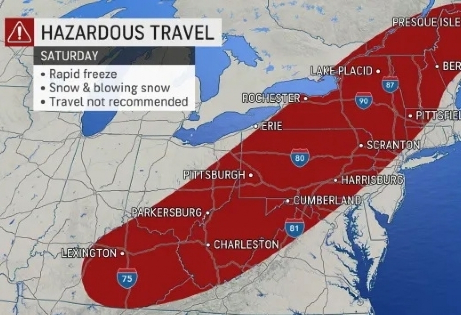
Winter storm watches and warnings were in effect from the Tennessee Valley through northern Maine on Friday as Mother Nature was preparing to serve up a late-winter blast of heavy snow, wind, rain and plunging temperatures, according to the AccuWeather.
With fewer than 10 days officially remaining in winter, more than 150 million Americans across the eastern third of the nation will face some impacts from the storm, including places along the Eastern Seaboard that began the week enjoying a spring preview with record-high temperatures.
AccuWeather meteorologists expect the storm to strengthen rapidly and even bring accumulating snow to the major cities along the I-95 corridor, a development prompted by the forecasters' expectation that cold air will plunge farther east faster than initially expected.
“A fast-moving and rapidly strengthening storm will bring intense weather and dramatic weather changes to the eastern half of the nation, with the most extremes in store for the Northeast,” AccuWeather Senior Meteorologist Dave Dombek said.
From a travel standpoint alone, major disruptions are likely on the roads and for those flying. Flight delays and cancellations are anticipated and could result in ripple-effect impacts across the country.
“The storm will have two distinct sides in terms of temperature and weather,” AccuWeather Chief On-Air Meteorologist Bernie Rayno said. The eastern half will be associated with warm air, areas of heavy rain, urban flooding, severe thunderstorms, isolated tornadoes and coastal flooding, Rayno explained. On the other hand, colder air will catch up with the storm, and temperatures will plunge across the interior. That will lead to heavy snow, white-outs and localized blizzard conditions as well as a rapid freeze-up.
Even though the snow portion of the storm is likely to last only eight to 12 hours across the interior Northeast and perhaps just a few hours or less near the coast, impacts will be significant.
The storm moved northward from the central Gulf coast Friday night and will track along the Eastern Seaboard on Saturday. Its path will eventually take it into Atlantic Canada later in the weekend.
Some of the higher totals from this storm so far have fallen in places like Columbia, Missouri, and Perryville, Arkansas, where 5-6 inches were reported, but that was only the beginning.
Following a light to moderate snowfall, on the order of a few inches in portions of the lower Mississippi and Tennessee valleys on Friday night, a swath of moderate to heavy snow will expand northeastward over the Appalachians, including the slopes and valleys that extend to the immediate west from Tennessee to Maine.
Accumulating snow will also reach the major I-95 cities from Washington, D.C., and Philadelphia to New York City, and the blast of winter weather in this zone will unfold in dramatic fashion.
Temperatures on Saturday morning will be in the 40s and 50s along I-95 in the mid-Atlantic and New England ahead of a press of Arctic air. Temperatures will plunge 10-20 degrees in a few hours’ time and cause rain to change to snow. By the end of the afternoon on Saturday, temperatures are likely to be close to the freezing mark.